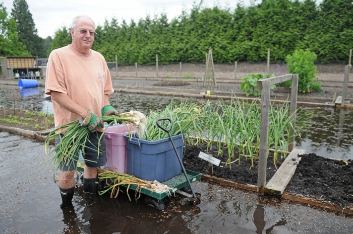
If flood waters do not recede soon, Glen Valley’s Frederick Munn could lose the estimated $30,000 to $40,000 he has invested over three years in an organic soil test garden at West Creek Farm.
Munn, co-owner and general manager of the farm on River Road, said this is the highest he has seen the floodwaters rise since he came to the farm in 2000. The front fields have become a miniature lake, his raised garden project is nearly hidden under 10 inches of water and a pile of peat moss located at the side of the property will have to be moved to higher ground.
"This is the worst year so far," he said, while picking garlic plants from the garden, in an attempt to salvage them. "The water will rot the roots off the plants because they won't get any oxygen," Munn explained.

On Friday afternoon, the water was seeping up from the water table, but should the Fraser River overflow into West Creek, which runs beside Munn’s property, flooding could get far worse, he feared.
“I’m disappointed, it’s a lot of work kind of wasted,” Munn said. “On the other hand, compared to people who are worried about losing their houses, this is definitely a relatively small loss.”
West Creek Farm is among 147 residences, farms and businesses in Glen Valley, Northwest Langley, Brae Island and McMillan Island that were put on evacuation alert by the Township of Langley.
On Friday, the city of Abbotsford issued an evacuation order for some Glen Valley residents who no longer have access to their properties due to roads flooding. No evacuation orders were issued for Langley residents, but many low-lying roads were closed. Parts of River Road, 264 Street between 84 Avenue and 88 Avenue, Fort Langley’s Marina Park and the boat launch were shut down after water began spilling onto them.
“We are keeping a very watchful eye on the river and the weather,” said Township Director of Public Works Roeland Zwaag. “So far, it is holding steady, although people in areas unprotected by dikes have been told they may have to leave quickly, should that situation change.”
The majority of Township land by the river is protected by dikes, which are still holding up very well, Zwaag said. Engineering staff will continue to patrol the area.
“We just want to make sure everyone is safe,” Zwagg said. “We don’t want to endanger anybody. (We want to) make sure everyone stays safe and keeps away from these danger areas.”
In Derby Reach Regional Park last Wednesday, dozens of children of H.D. Stafford Middle School were enjoying a lazy day in near-perfect early summer weather.
Closer to the Fraser River, other people gathered around picnic tables not yet submerged in the surging river that was steadily rising from melting snow and plenty of spring rainfall.
The Edgewater camping grounds were out of bounds, some of them under inches of water. Only pedestrians were allowed to walk on the path.
Closer to Fort Langley, the Fort to Fort trail was cordoned off, but some people were ignoring the warnings, a Township official noted.
The trail immediately east of the Bedford House restaurant was also closed off as the Bedford Channel waters inched further and further inland.
At the site of the former Fort Langley-Albion Ferry, a security guard was preventing the curious from venturing down the boat ramp.
“It’s for their own safety,” said the guard, who would only allow boat owners access.
As of Monday afternoon, water levels remained high but stable. Weather forecasts indicate cloudy weather for much of the week, and the river is expected to remain high.
For more information and flood watch updates visit www.langleyemergency.ca or the Township of Langley website www.tol.ca.
— with files from Natasha Jones
