Boundaries and an engagement strategy for completion of the undeveloped area of the Brookswood/Fernridge Community Plan were endorsed by Langley Township council on Monday, Jan. 25.
There has been confusion over whether or not Brookswood and Fernridge have been divided (see “The Great Divide,” published in The Times Jan. 27).
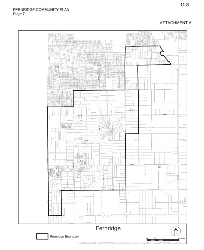
The Times wrote, “Fernridge is now considered a separate area from Brookswood, with a border that starts at 196 Street and traces along 33A Avenue, up 200 Street to 36 Avenue, and then up 208 Street to 43 Avenue.” Rather, these boundaries separate the undeveloped rural area (which is commonly referred to as Fernridge) from the already developed area (which is commonly referred to as Brookswood).
Mayor Jack Froese has clarified that a new Fernridge Community Plan will not be created. Instead, an update to the existing 1987 Brookswood/Fernridge Community Plan will be completed with a focus on the undeveloped areas, separate from the already developed areas.
“What happened in 2014 (when a previous update failed) I think a lot of people were concerned that we were focusing on the developed area of Brookswood/Fernridge,” Froese told The Times on Wednesday.
“This time we want to make it clear that our focus is really the undeveloped area, which is primarily Fernridge.”
A map, shown in Attachment A of council’s report, shows this boundary.
“The map is just showing the area that is undeveloped — that’s all that shows — they’re not separating anything,” Froese said.
“I think that message somehow came out that we’re separating — we weren’t separating. I was just trying to direct people that we are focusing on the undeveloped area, somehow explain that, that we’re not creating something new.
“We’re not going to worry about the developed area, it’s already done.”
Froese further explained that the focus this time, as opposed to 2014, is on the undeveloped areas.
“What we have basically is the OCP from 1987. And the attempt in 2013-14 was to update it through current planning standards. Put in some of the protections that aren’t there as far as the environment and aquifers,” said Froese. “That failed. So what happened in 2014, I think a lot of people were concerned that we were focusing on the developed area of Brookswood/Fernridge. This time we want to make it clear that our focus is really the undeveloped area, which is primarily Fernridge.”
An extensive, five-stage process, integrating an enhanced stakeholder and public consultation program consistent with the recommendations of the Mayor’s Standing Committee on Public Engagement, will also be undertaken.
Focusing on definition, visioning, planning, and adoption, the communication and engagement strategy will utilize established tools, such as open houses and newspaper advertising, as well as new initiatives from videos to billboard signage, to educate and inform residents and solicit input. Face-to-face interaction will be offered through community and public open houses. Social media, including the Township’s website and its eAlerts will also play a key role.
A planning team made up of property owners, residents, members of the public, and community groups will be created to help the Township raise public awareness, ensure input is received, look at options, review information, identify community impacts and generally guide the process.
The process to complete the plan is anticipated to take 12 to 18 months.