I’m going to start this column by saying that if you disagree/would like to explain why I’m an idiot, you can do so through this handy link right here for letters to the editor.
There. Now that that’s out of the way, here’s three ideas that would massively change transit, traffic, and parking in Langley, and which many of you are just going to despise.
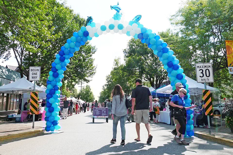
• Close Fraser Highway to cars
Not all of it, obviously. I’m not that crazy. Not yet.
But I think we should seriously consider shutting down the one-way section of Fraser Highway between 204th Street and 206th Street. Two blocks, that’s it.
I was actually around for the transition between two-way and one-way traffic on this stretch of road, and that change was not exactly greeted with unanimous praise.
In the years since, however, it has helped define Langley’s downtown core and revitalize a community of small businesses, not to mention providing a perfect venue for parades and festivals.
Making it a pedestrians-only zone takes that evolution a step further. The space between the curbs on Fraser Highway is immense, and valuable. Imagine the street tress and planters, the benches and outdoor cafés, the performance spaces, and the farmers markets that could replace road and parking spaces.
It’s also one of the few practical places for this in Langley, thanks to alleys and nearby 56th Avenue and Douglas Crescent, which allow access to the back of the stores on Fraser.
Would it be easy? In the long run, the City might have to look at creating some extra parking off Douglas or 56th, or at the east end of the one-way section. But with sufficient wheelchair parking north and south of the section, it certainly seems feasible.
Also of note – this stretch of road is just around the corner from Langley’s bus loop, and a block from the proposed end point of the SkyTrain line. It’s already the most transit- and pedestrian-friendly spot in Langley City.
• Put parking meters in Fort Langley
I’m not even going to argue that this is an idea for the far future. This would benefit the Fort right now.
Fort Langley’s core is a 19th and early 20th Century village, turned weekend tourist hot spot. It has parking sufficient for horses, buggies, and Model T Fords, not for thousands of sedans, hatchbacks, and pickups visiting to see the Cranberry Festival or JazzFest.
The village needs metered parking, at the very least on weekends and during special events. A system of resident parking permits on the south end of Glover, and employee parking on the north end, is necessary so there’s decent turnover in visitors during the day.
Fort Langley is the White Rock of the Fraser River. It’s a town defined by natural beauty, heritage, good food, and swanky shopping. Pay parking is one of the only ways to make sure trying to find a space doesn’t become even more of a nightmare.
(Also nice would be a bike share system with nodes in Walnut Grove and at TWU, to give young adults a car-free option to get to and from the Fort for jobs and recreation.)
• Turn Walnut Grove into a grid
This one might be the most controversial.
Take a look at Langley City’s downtown, or Aldergrove, Brookswood, or the Fort, and you see the same basic street plan. There’s a few major arterial roads, and the neighbourhood spreads out around those in what’s more-or-less a grid pattern.
Not Walnut Grove.
The only major Langley neighbourhood planned in the 1980s, it’s a hymn to cul-de-sac-based suburbia. Twisting networks of roads that dead-end abruptly form huge swathes of the community, especially north of 88th. The arterials don’t directly connect across to one another except at a few major intersections – try driving from 208th Street to 216th Street anywhere but at 88th or 96th Avenues – streets that are a full mile apart. How about 204th Street to 208th? Nope!
I understand why this type of suburban planning was, and in many ways still is, desireable. Cul-de-sacs and short, twisting roads make for slow traffic and places where kids can (theoretically) play street hockey or learn to ride their bikes.
They also mean the creation of a transit desert that can never be adequately served by bus, that doesn’t allow people to walk to shops or services, and that drives up greenhouse gas emissions and a car-dependent lifestyle.
It needs to change.
Walnut Grove’s future must contain connectivity, and in places, increased density.
A long term community plan is needed that identifies new places to connect the streets into a grid. Corners at quarter miles should, in the future, be sites of mixed-use commercial and residential development. Yes, low-rise condos and townhouses. No, they will not immediately drive your property values down.
Walnut Grove already has one of the community’s best networks of walking trails, connecting its many excellent parks. It could, in 30 years or so, become a modern, walkable community while preserving many of the features its current residents like.