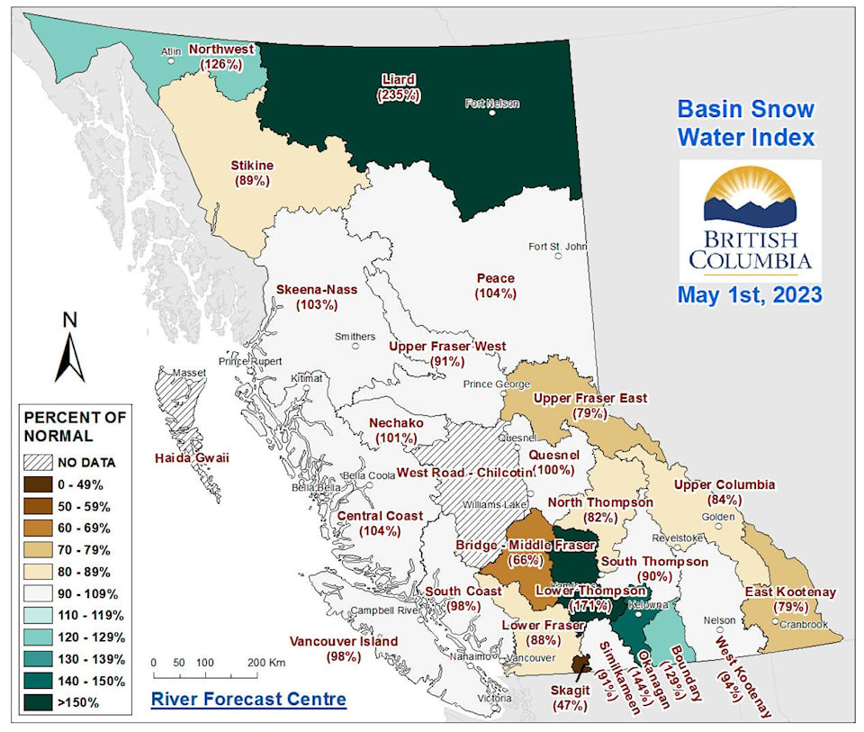
Snow levels in the Boundary, Okanagan, Nicola, Liard and Northwest basins in British Columbia are significantly higher than normal.
The May 1 snow data from the BC River Forecast Centre, released earlier this week, showed the snow levels in the province are at 91 per cent of normal levels, although there are some exceptions. The data is compiled from 97 manual snow courses and 97 automated snow weather stations around the province.
While April temperatures were cooler than normal in much of the province, the sudden warm weather in late April and early May resulted in rapid melting.
Another high-pressure ridge is expected to affect the province on the weekend of May 13 to 14.
READ ALSO: Snow levels below normal in most of B.C.
READ ALSO: Summerland snowpack significantly higher than normal
The Liard basin is at 233 per cent of normal levels, while the Northwest basin is at 126 per cent of normal.
The Nicola basin is at 150 per cent of normal, the Okanagan basin is at 144 per cent of normal and the Boundary basin is at 129 per cent of normal.
In addition, while the Middle Fraser basin is at 87 per cent of normal, the Lower Thompson sub-basin of this region is at 171 per cent of normal.
The lowest snow measurement in the province was the Skagit basin, at 47 per cent of normal.
While flooding is a risk each spring, the areas with above-normal snow measurements are at higher risk of flooding this year, the report from the BC River Forecast Centre states.
“In general, the most common cause of major spring flooding in B.C. is a period of persistent cool temperatures and wet weather into the spring, followed by a sudden heat wave of at least five or more days,” the report reads. “The start of widespread snowmelt this year was triggered by this type of heat event in late April/early May.”
The risk of flooding from melting snow is expected to continue in the coming weeks. When the snow pack is depleted, heavy rainfall will become the primary driver of flood risks.
While the snow pack is one factor in the risk of flooding, it is not the only one, the river forecast centre states. Spring and early summer weather can affect the timing and rate of snow melt.
Flooding is possible in areas where the snow pack is lower than normal, and a high snow pack does not necessarily indicate flooding will occur.
To report a typo, email:
news@summerlandreview.com.
news@summerlandreview.com
Like us on Facebook and follow us on Twitter.
