A legal document dated November, 2003 sealed an agreement between CN Rail and the Township of Langley for a pedestrian walkway that would link the Bedford Landing housing development with the rest of Fort Langley.
When plans were first unveiled for Bedford Landing on Fort Langley’s waterfront, residents raised concern about pedestrian access between the development and the village. What made that access particular challenging was the double set of railway tracks separating Bedford Landing from the village.
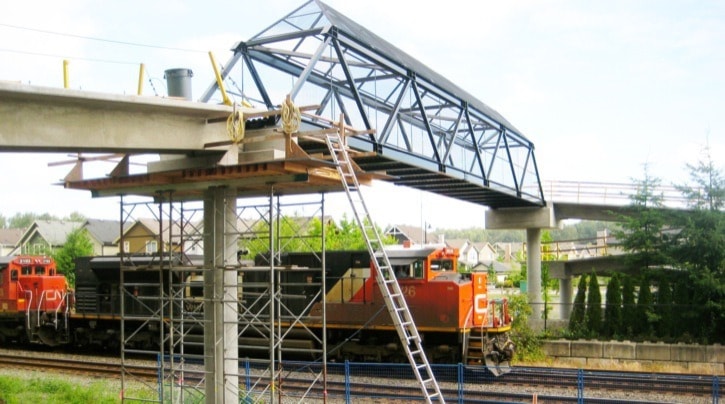
Now, nine years later, work on the overpass is almost complete, but some of the residents who are impacted the most say they were kept in the dark about the location until groundwork began for the footings in the spring.
One anchor of the pedestrian overpass is right on Gord Clemett’s doorstep.
Clemett is upset for several reasons, not least of which is that he wasn’t advised that a walkway support would sit at the edge of his property at the end of Marr Street, and nor were several residents on Edal Street.
 Furthermore, a long and narrow stretch of trees may be chopped down to accommodate the walkway, obliterating what is now a noise barrier, he said.
One day in May, Clemett came home to find a huge hole dug only feet away from the northerly edge of his house. A big gap from the felled trees will be filled in soon enough by the elevated walkway, spoiling his privacy.
“I’m sure a better position of the ramp and pathway could have been designed to minimize property impact,” Clemett said.
“There was no notification about the construction,” he said, questioning whether ParkLane (developer of Bedford Landing) can legally build a structure so close to his property.
“There is no sensitivity for the lifestyle of the people who pay the taxes,” Clemett said. He wonders why the overpass is not being built closer to Glover Road, and is not happy that his complaints to Township hall have gone unanswered.
ParkLane, he said, is calling the shots.
His written complaint outlined his concerns: No notification about the construction, commercial structure within nine metres of a suburban property, the negative effect on the septic field, property devaluation and lack of compensation.
ParkLane held several meetings with Fort residents after the Bedford Landing concept was hatched from Equitas’ Watercolours development and, said Deana Grinnell, ParkLane’s director of land development who was heavily involved in the process, the earliest documentation contemplated the overpass where it is being built now.
However, something has obviously gone awry, as so many residents were caught unawares, Clemett said. He maintains that prospective house buyers on the south side of the railway tracks are shying away, mainly, he said, because the removal of trees means the noise of trains is more pronounced.
His Marr Street neighbours Ela and John Mis are not happy, either. They say they feel betrayed by the Township, and that the trees and shrubs that lie between their home and the railway tracks will be needlessly destroyed.
They said that during the open houses/town hall meetings, residents were told that the pathway would be placed as far as possible from existing property lines.
They believed that the path would be approximately about 8 to 10 feet south of the existing CNR fence.
“Over the last year there were some surveys conducted and every one of them was bringing the pathway closer and closer to our property line,” they wrote in an email to Township staff.
They point out that residents were given to believe that the gravel trail would be built through trees, connecting with the end of Edal Street and the west end of Mavis Avenue.
The trail was shown to be 20 to 25 feet north of the existing property lines, placing it downslope from the existing houses.
“As a condition of trail work in this area the developer, ParkLane, is required to undertake a tree survey and arbourist’s report with the intention of maintaining as many trees as possible along this corridor with the final alignment of the trail,” they said.
“Our understanding of the above statement was that the trail would be aligned with the existing trees and not the other way around. Now, it seems like it would run in a straight line no matter how many trees or bushes would have to be cut down.”
It would be to everyone’s benefit if the pathway was built on the north side of the visible berm, they added.
The walkway does not eliminate two existing ground-level crossings of the railway tracks, at Glover Road and 96 Avenue.
Another overpass has been suggested to carry pedestrians over the railway track and River Road from the National Historic Site to the east end of Marina Park.
Al Neufeld, the manager of parks and development for the Township, said that talks with the federal government, owners of all the pertinent land, have not gone beyond informal discussions.
The price tag is pegged at between $1 million and $1.5 million.
Pedestrians access the overpass from Billy Brown Road on the southern end of Bedford Landing homes. The elevated walkway’s westerly edge lines up with Marr Street, a cul de sac.
The Township formally approved the overpass location in September, 2010.